As the original hunter gatherers of prehistory found scope for wandering limited by growing numbers, they settled into small, family communities. Surviving, as best they could, the depredations, even enslavement, of the new arrivals… the Gaels, Saints and Vikings…and eventually merging into them through interbreeding, numbers of such family groups of housing increased. Evidence of this is plentiful in Ardnamurchan, as well as that of the grouping into larger ‘families’, that we now know as Clans, with the Clan chief taking responsibility for such as land allocation.
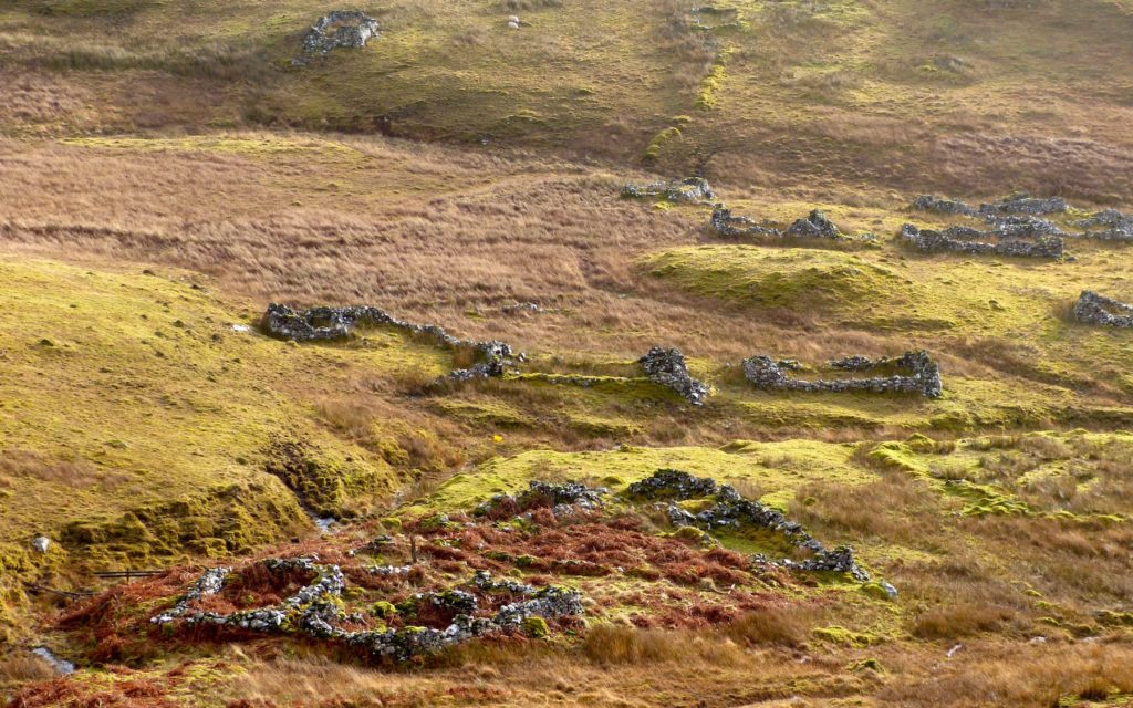
The photo above shows Bourblaige, a settlement cleared in 1828 – consisted of a few, very simple dwelling houses, each with farm outhouses such as byres and barns, and kaleyards, walled areas for growing vegetables, occupied by a population, typically of around 30, many of whom were related. The people lived in single-storey buildings made of local materials including wood, turf, reed, heather and, later, stone – of which the two-roomed blackhouses are the best known.
One of the problems of understanding the history of the settlements is that, for centuries, the structures, including the houses, were built of materials, such as wood for the roofs and peat turfs for the walls, which have left no trace. To add to historians’ difficulties, many of these impermanent structures may have been destroyed on a regular basis, the materials, often saturated with soot from the fire, used as fertilizer on the fields, and a new house built either on the old site, or on a different one. It was only relatively late on, during the 18th century, when ‘improving’ estate owners such as Alexander Murray began to insist that their tenants build houses using stone for their walls.
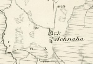 This map of Achnaha, taken from the OS 6″ map surveyed in 1872 [1] , illustrates the arrangement that is perceived as being typical of a nucleated settlement, with the houses close packed but often at random angles to each other, and usually sited on the poorest ground, surrounded by arable fields. However, there is good evidence that this is only a recent arrangement, that earlier ones had the houses much more dispersed. In Bourblaige, for example, the houses were further apart, but even earlier settlements may have had the houses still more dispersed, with individual or, sometimes, small family groupings within a walled enclosure. The farming system used by the settlement population also changed through time, though the land was always treated as a communal asset.
Where reasonably large areas of good arable ground was available, open fields were divided into strips about 6m wide. The earth was banked into ridges (rigs) with weed-filled ditches (runs) between, a system known as runrig. This arrangement aided drainage, and thickened the soil for the crops which were grown along the top of the rig. In some places, these strips were allocated by the drawing of lots on a regular timetable.These strips were fertilized with bracken or, better, by applying seaweed, and could be very fertile. They were worked using hand tools such as the caschroim, a type of spade.
Large areas of good land are uncommon in most highland areas, so the small, irregular patches between rock outcrops, where a plough could not be used, were organised into strips about 2m wide called lazy beds or feannagan. The strips were often S-shaped, a feature which was dictated by the use of the very unwieldy, wooden old Scotch plough. The allocated strips would be worked by the family for as little as a year and then reallocated, sometimes by drawing lots, so the better fields were available to all. The system was much criticised by later ‘improvers’, since there was little incentive to develop the soil of a strip, as this would benefit future as much as the present users. The picture shows lazy beds in Ormsaigmore.
The system was improved by having more permanent individual use of the runrigs and by the later introduction of James Small’s all-metal plough, which could cut a straight furrow and be used in much smaller areas. A further important development, after about 1755, was the widespread planting of potatoes. Prior to this, the potato was only grown close to the houses, in the vegetable patches called kailyards. As a result of the improved nutrition offered by bulk potato growing, the population soared. This meant that existing land had to be subdivided more and more – which caused a disaster when blight came to the Highlands and Islands in 1846.
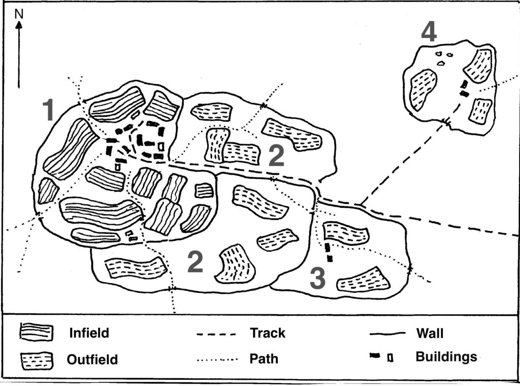
This map, adapted from Robert Dodgshon’s book [2], gives a vivid idea of the layout of a settlement and how it may have developed. The area 1, within a wall called a header dyke (a stone or peat wall), enclosed the buildings of the settlement and the well-fertilized infield arable fields. These fields were liable for assessment by the tacksman (Gaelic fear-talc) who acted on behalf of the clan chief. Developed beyond this boundary, 2, and enclosed by an outer dyke, were one or more outfield areas. The fields in the outfield were fertilized by the animals being brought in and contained within them by temporary dykes and were not assessed for rent purposes. With a rising population, further areas, 3, could be developed and settled. Outside these areas lay the common grazings, upon which each family had a right to graze a fixed number of animals, a souming. The area 4 was originally a shieling (Gaelic airigh, see next paragraph) but this, too, could be settled on a permanent basis.
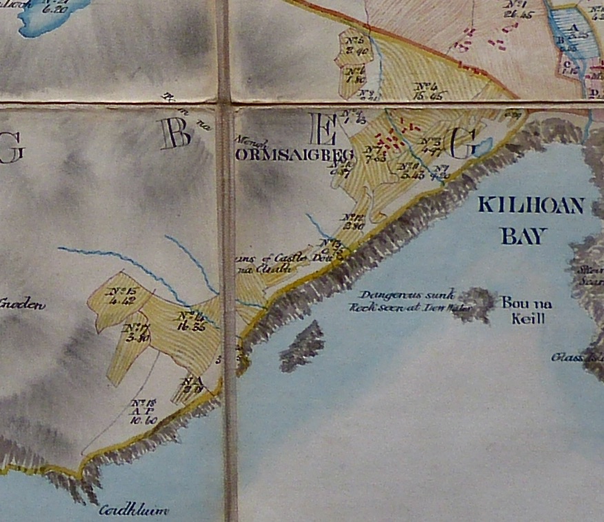
This arrangement can be seen in Bald’s 1806 map [3] of Ormsaigbeg. The buildings of the settlement, in red, and what were probably its infield lands are at top right, but the outfield stretches for some distance along the shores of Kilchoan Bay and into the hills behind. There is some evidence from Roy’s map that buildings were also constructed some distance to the southwest – see the history of Ormsaigbeg, here.
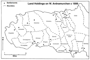
This map, also based on Bald’s map of 1806, shows the settlement lands of western Ardnamurchan. So, as well as the better land immediately around the settlement, each settlement had rights on a large area of common hill land, the common grazings, upon which to keep its animals. In summer, the cattle and sheep were taken to a distant part of the common grazings where the women and children stayed in shielings and made products such as cheese, while the men worked the arable land for crops of barley, oats and, later, potatoes. The animals were brought back to the settlement once the crops were harvested, and grazed in the infields to manure them. Many settlements grew up close to the sea, as this provided a good fertilizer in the form of seaweed, and the opportunity to supplement what was otherwise a meagre diet through collecting shellfish along the shore, and fishing.
All the settlement lands belonged to the clan as a whole. The population paid both allegiance and rent to their clan chief through a tacksman who collected the rent – in kind or in cash – and led the menfolk in clan wars. In return, the clan offered its people protection, security, access to land and, in old age and sickness, a sort of ‘social security’. To quote Donnie Fraser, “Underpinning the whole structure of clanship was the almost untranslatable Gaelic term of duthchas, a sort of collective heritage, a concept which guaranteed the right of the people to the land, not necessarily a specific plot of land but a permanent and hereditary stake in the clan territories as the common property of all.”
[1] National Library of Scotland – here. [2] Robert Dodgshon ‘The Age of the Clans’ – Berlinn with Historic Scotland – 2002 [3] Courtesy Ardnamurchan EstateTHE CLANS:
Although its roots probably evolved from the early tuath society in Ireland, and some clans claim origins in Celtic mythology, a distinctive Scottish clan system was established by the 11th century, around the time when Malcolm Ceanmore became king in 1058. The system developed as local war lords, in this chaotic period , seized the opportunity to impose their dominance over local families who accepted their protection. Some chiefs had a Celtic background, others were Norse-Gaelic or British; later ones were Norman or Anglo-Norman.
The word clann means children, reflecting both that its members had a kinship and the relationship between the people and their chief, the Ceann-cinnidh. He was the symbol of the clan, the dispenser of justice, the leader of its army, and the defender of its territory. Once elected, he had considerable power but was constrained by customs and traditions. A chief who proved to be inadequate could be removed. The system ensured that the clan was always strongly led and ensured that the chief acted in the best interests of those whose support he depended upon.
Below the chief were the daoine uasal, later known as fir-tacsa or tacksmen. They were usually close kin to the chief and were responsible for the day-to-day administrative tasks vital to the clan’s existence, such as the division of arable land between settlements, while in times of war they were the military officers with responsibility for raising and leading the various units in the clan’s fighting forces.
Underpinning the whole structure of clanship was the concept of duthchas, a concept of collective heritage, a sense of belonging to a certain area of land, of being rooted by ancient lineage to a particular place that was communally held by all the people of the clan. It embodied the responsibility of the clan elite, and the chief in particular, to act as protectors, guardians and benign administrators, who guaranteed security of land tenure in a world in which, for the vast majority, ownership of land was the basis of individual survival.
The MacDougalls:
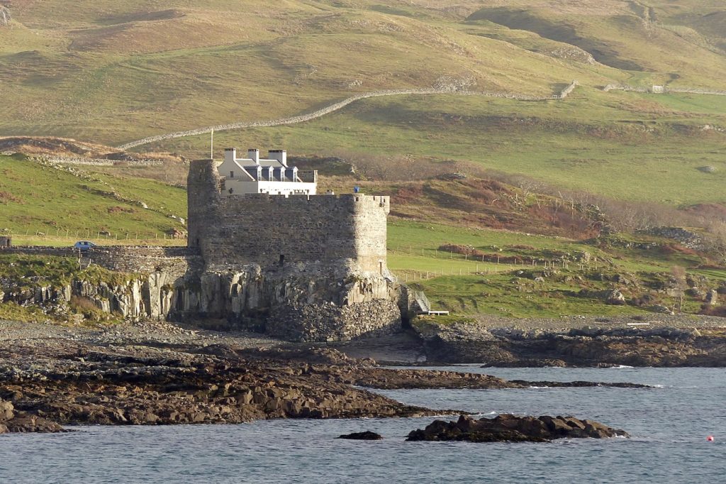
It seems likely that the first recognisable clan to hold Ardnamurchan was Clan MacDougall. Their founder, Dugald, was the eldest son of Somerled but it was the next generation who, by supporting King Alexander II in his struggle to control the western mainland, rose to considerable power. Alexander MacDougall of Lorne, lord of Argyll, continued his support for the crown, aligning himself with King John Balliol and gaining a huge territory that stretched from Ardnamurchan in the north to Knapdale in the south. It is probable that, during this time, Mingary Castle (above) was built at the northern end of the MacDougall holdings to control the entrance to the Sound of Mull.
Alexander’s continuing support for Balliol against Robert the Bruce resulted in the loss of all his lands after Bannockburn in 1314. Some time before 1320, King Robert confirmed Angus Og MacDonald, lord of Islay, in the lordship of much of the MacDougall lands, and he passed Ardnamurchan to his brother, John Sprangach ‘the bold’ MacDonald.
The Maciains:
John Sprangach MacDonald was the founder of Clan MacIain, which held Ardnamurchan for the next three hundred years.