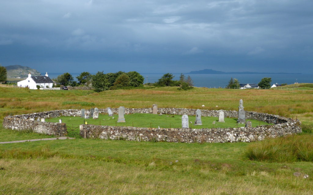
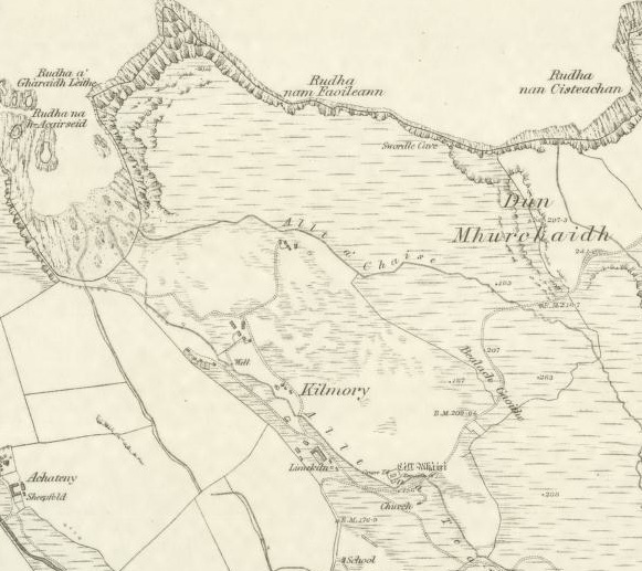
Kilmory is a small crofting township on the north coast of West Ardnamurchan. Its resident population at the time of writing is eight, and much of its croft land is underused, but it once had a much larger population, and is probably very old. Its name refers to the church that once stood there, Cill Mhoire. This is said to have been associated with the walled churchyard, pictured above, which contains carved tombstones which are believed to be very old – though they are difficult to find today. However, one long-time resident of the township told me that she did not believe that the churchyard was very old.
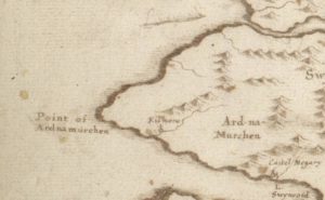 In 1541, the tenant was recorded as Johne Erenoch and the land valued as 2½ merk land [1]. The earliest map that records Kilmory is Robert Gordon’s map dated 1636-52 and titled ‘Straloch’s mapp of Scotland and The West coast from Glen Elg to Knap-dail’ [2]. Kilmory is marked on the south side of Ardnamurchan, roughly where one would expect Kilchoan to be, with ‘Castel Migary’ to its east. It may be that this is Kilchoan, but a subsequent map by Gordon, of a similar date to the first, entitled ‘A map of Scotland, north of Glenmore in detail, and outline of the east coast to Dunbar, showing the courses of the chief rivers, and the positions of a few places’, shows it in its correct position on the north coast.
In 1727 a survey was carried out by Sir Alexander Murray of Stanhope. Called ‘The Anatomie of the Parish and Barony of Ardnamurchan and Swinart’, it included a table in which he listed details of all the Ardnamurchan settlements. The ‘Kilmorrie’ population included ten men, ten women and eight children, a total of twenty-eight souls in eight families. The land was valued at ‘4 Penny-land’ – compare this to Achateny, 6, and Achosnich, 9 – and the area of its land was given as 1100 acres. For its souming – the number of animals it was permitted to keep – it was lumped in with ‘Swardilchorach’, the totals being 108 ‘cowes’, 27 horses and 108 sheep. Its ‘Natural and Uncommon Product’ was given as ‘Sea Ware’ (seaweed used as fertilizer) and limestone.
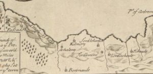 This much more detailed map (left) was published in 1733. Termed ‘A plan of Loch Sunart’, it was surveyed by Alexander Bruce and Richard Cooper.
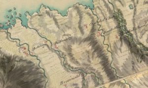 William Roy’s Military Survey of Scotland, 1747-1755, right, shows ‘Killmorey’ clearly, though well back from the coast. Roy’s map was a masterpiece for its time but, while it’s possible to infer something about the relative sizes of the settlements, it would probably be wrong to think that Kilmory in those days consisted of three houses.
Kilmory is unfortunate in being located on one of the joins of William Bald’s superb map ‘Ardnamurchan and Sunart the property of Sir James Milles Riddell, Bt.’, published in 1806 on a scale of 1:11,600 [3]. It shows considerable detail of the settlement, marking seventeen buildings and what may be a walled enclosure, though the accuracy of the number and position of the buildings is in some doubt. Interestingly, he marks a ‘Meeting House’ to the southeast of the settlement. His survey of the fields is remarkably accurate, and shows that Kilmory was a typical settlement at the time, a small, nucleated settlement with its commonly-held arable fields surrounding it. It also had a large amount of common grazings, which extended south half way across the peninsula.
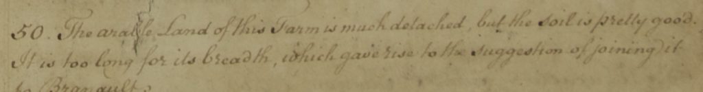
At the time, the Ardnamurchan estate was losing money, which was one reason for Bald’s survey. While Bald only made a detailed inventory of the land, the following year Low reviewed Bald’s work with suggestions as to what Sir James should do with the lands he owned. He named the principal tenant or tacksman and the Kilmory acreages as follows –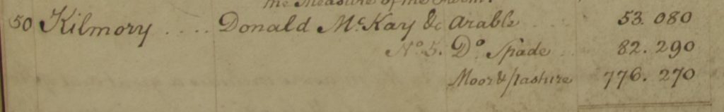
There is no evidence from within Low’s document for the settlement’s population. However, Low added the following comment –
In the reorganisation of his Ardnamurchan Estate that followed, Sir James Riddell did not clear Kilmory and amalgamate it with Branault as suggested, preferring to use Kilmory, at a later date, as a haven for the people of the many settlements he did clear in the years following 1828.
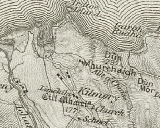
The first OS map, dated 1856 [2], shows Kilmory reduced to no more than eight buildings, a school and a church. That there are so few houses is surprising as it had, by this time, accommodated, but perhaps already lost to place like Sanna and Portuairk, people cleared from the three Swordle settlements. Just to the northwest of the church is a small enclosure, marked as Cill Mhairi, the walled graveyard – though it appears unlike the graveyard today, what is round.
By this time the settlement had been reorganised as a crofting township. That there is no sign of the field boundaries which came with this change is due to these boundaries never being demarcated by walls, as in many of the other townships.
The school is an important addition, lying on the the border between Branault and Kilmory.
 The next OS map, surveyed in 1872 and published in 1875 on a 6″ scale [2], shows a much larger settlement, with 23 buildings and the church. The walled graveyard, Cill Mhairi, is shown, but it is surrounded by a sub-rectangual wall and has what may be a rectangular building within it. New additions included a well and a limekiln. By 1897 Kilmory had eight crofts, each of which had a main area of arable land. However, since this was of generally poor quality, the best land, at the southeastern end of the township, was divided into thin strips and allocated between the crofts.
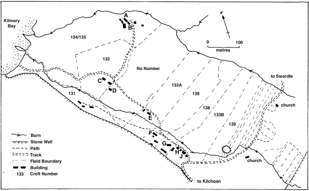
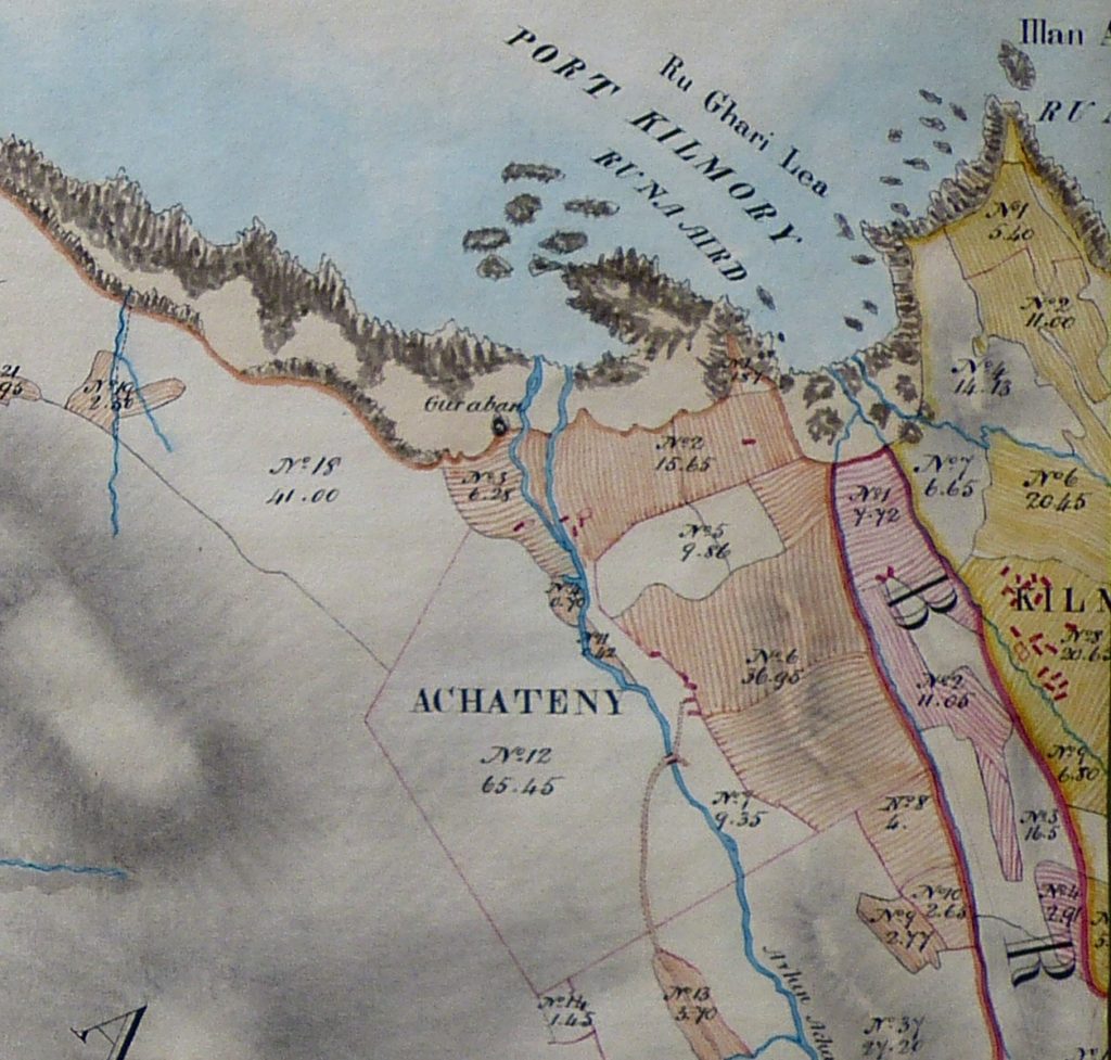
The map is taken from the booklet by Joey MacKenzie, whose family had lived in the township after being cleared from Swordle Corrach. The main field of each croft is numbered but, because these are generally of poor quality, each croft was also given one or more of the narrow strips of better land at the southeast end of the township. The booklet, which describes Joey’s life in Kilmory as a girl in the 1930s, is available in Kilchoan shops. In 1948 large areas of the existing Ardnamurchan Estate, including Kilmory, were parcelled up by its then owner, Lord Trent
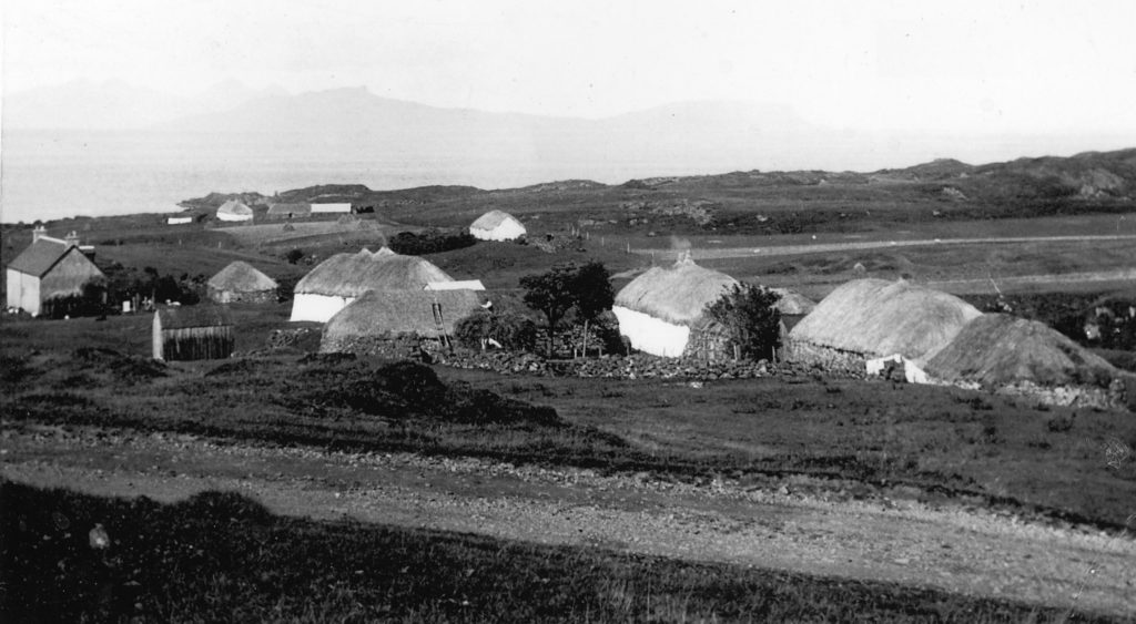
This and the next two pictures were all taken in the 1920s, and they show different views of Kilmory. At the time, most of the houses were still occupied, and the croft fields were still being worked [4].
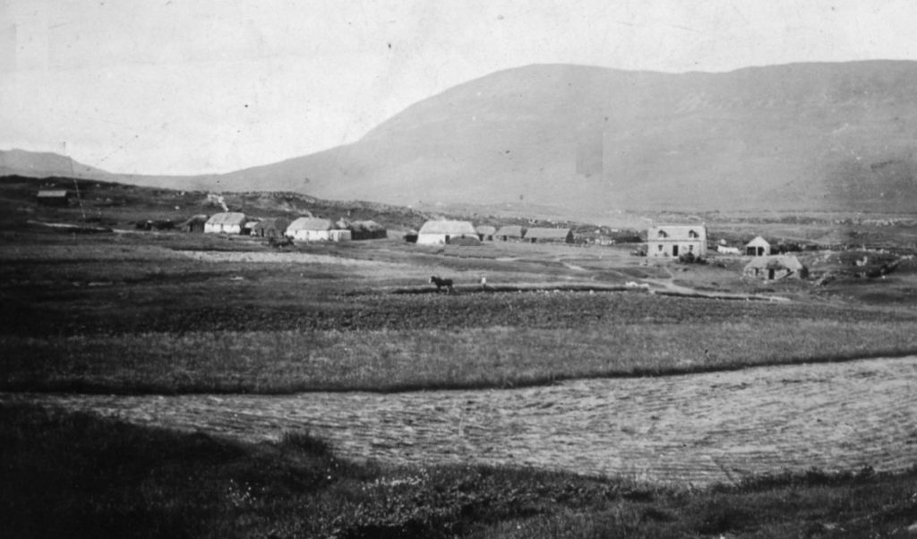
The horse in the centre of this picture, called Dan, was used for most of the heavy work on the crofts [4]. More details are available on the West Ardnamurchan Vintage Photograph site, here.
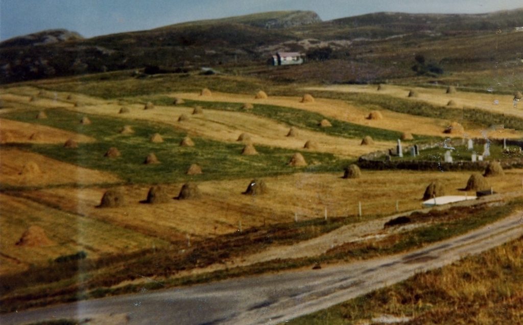
This early colour picture of Kilmory taken in the 1960s [4] shows the old Free Church building that used to stand along the road towards Swordle. The walled graveyard, Cill Mhairi, is visible to the right, and the Church of Scotland building, now a private house, is off-picture away to the right. The fields were still being worked. All lie fallow today, grazed by sheep.